William Parker, 1604-1673 Parker's Clifts and Parkers Creek
On this page . . .
Emigration from England, Settlement in Virginia
William Parker was a mover and shaker, a sponsor of Puritan settlement first in Virginia in the 1630s and then in Maryland in the 1650s. Born about 1604, he probably belonged to the English Parker family of Great Bloxwich in the English Midlands and St. Antholin's in the City of London–a prominent Puritan family that included rich merchants and generous benefactors. From his base at Stepney–now part of London's East End–William Parker's interests ranged far and wide. He owned shares in ships hired by the English Merchant Adventurers of Hamburg for their journeys the world over, including one called the Richard and Martha. The focus of his enterprise, however, was the Chesapeake. It's possible he served a sort of apprenticeship there as early as the 1620s. Certainly by 1636 he had set up a trading enterprise in merchandise and tobacco near Virginia's Dumpling Island, in the Nansemond River.
Nansemond, Virginia, was home to Richard Bennett's Puritan community west of the James River and Norfolk, from 1635 to the late 1640s. It is labeled as Nantemond on Augustine Herrman's map
Virginia and Maryland as it is planted and inhabited this present year 1670, published in London by Augustine Herrman and Thomas Withinbrook, 1673.
This detail from the map has been rotated so north is at the top. Dumpling Island, not shown here, lies on the Nansemond's main stream about one mile west of its confluence with the Western Branch.
Image from the Library of Congress,
https://www.loc.gov/item/2002623131/,
consulted 21 June 2025.

Puritans Move to Maryland, Parker is Granted Land
Thanks to the tobacco trade, the Nansemond Puritans prospered until 1649, when the English Civil War came to the Chesapeake. The Royalist Cavalier government in Virginia targeted the Puritans, limiting the practice of their faith and their ability to hold office. Lord Baltimore, desperate for settlers to build up his fledgling colony, invited the Puritans to take up unsettled lands in Maryland and guaranteed them religious freedom through the Act on Toleration. An odd mix of Lord Baltimore's Catholic friends and anti-Catholic Puritans–William Parker among them–organized flotillas to bring the settlers and their families up the Bay.
Like most of the Puritan vanguard, Parker settled first along the Severn River, patenting 200 acres at what is today known as Ridout Creek. As a major sponsor of the migration, he received headrights for additional lands, including an 800-acre survey on the cliffs in the northern section of Calvert County, immediately adjacent to Richard Bennett's Upper Bennett plantation. For unknown reasons he swapped this survey on June 25, 1652, with Col. Thomas Burbage and Maj. John Billingsley for the rights to 600 acres of land, which he then seated further south along the Cliffs, naming his tract Parker's Clifts. The creek that entered the Bay within the southern part of the grant became known as Parkers Creek. [Endnote 1]

Parker’s Clifts certification, 1658, with reference to the 1651 survey.
Maryland State Archives, liber AB&H, folio 287 (microfilm SR7344).
Parker probably set his indentured servants to clearing the land and cultivating tobacco and set up members of his family to oversee plantations. By this time the Parker community consisted of a variety of laborers, his several daughters by his unknown first wife, two stepchildren belonging to his second wife Grace (the widow of Francis Mauldin), and the two children they had together including his only son William Jr.
Parker's Clifts, surveyed 1651, patented in 1658. The underlying basemap is as-of 2024. The green dashed lines represent ACLT hiking trails.
For more on land patents and a discussion of how the Parkers Creek Heritage Trail project made a
"best effort" to develop its maps, see

Parker's Role in Maryland Politics
Although their move from Virginia took advantage of the Act on Toleration, the Puritans carried out a series of actions intended to undercut the Calverts. In 1654, Puritans succeeded in removing Maryland's governor. In 1655, a small force of Catholics and non-Puritan Protestants attempted to restore the governor, but they were defeated by Puritan forces in the Battle of the Severn. After the battle, William Parker was named one of the ten commissioners that governed the province.
In 1654, Parker had been named as a member of delegation to negotiate with the "Indian Empiror," which we believe referred to the paramount Piscataway leader often identified as Tayac. The delegation was led by the prominent Puritan Richard Preston, also a resident of Calvert County, and included Sampson Waring, William Parker's next-door neighbor at Parkers Creek.
-
It is ordered by the present Generall Assembly That mr Richard Preston, mr William Parker, mr John Lawson, mr John Hatch, mr Sampson Waring mr Cuthbt Phenwick, mr John Wade, mr Arthur Turner mr William Parrott . . . are Authorized by vertue hereof to treat with the Indians Empiror as in their Discretion they shall think fitt, Concerning the former Articles Concluded with him or to make others if need shall require . . . . [Endnote 2]
Meanwhile, 1658 saw the return of peace in Maryland and the restoration Calvert family. In this context, William Parker focused on developing his plantations at the Cliffs, selling his Severn River home in 1660. He continued to ply his merchant's trade, while his only son William–known as William Parker "of the Clifts"–and son-in-law Henry Kent maintained the plantations. William eventually returned to England, dying at his home in Stepney in 1673.
After William Parker's Death in 1673
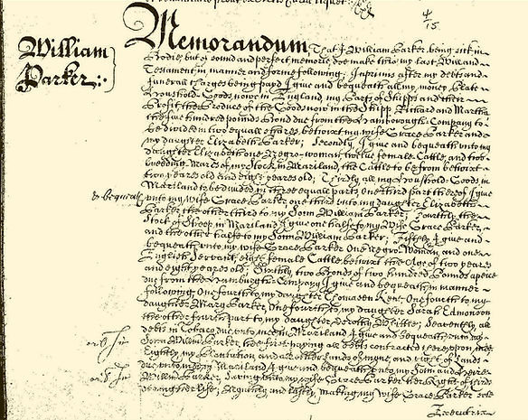
First segment of William Parker's will, 24 July 1673.
From the U.K. National Archives, Kew;
Prerogative Court of Canterbury, PROB 11/342/453.
Parker's will includes numerous provisions, including a bequest of his land in Maryland to his son, noting the customary dower right reserved for his widow.
-
. . . my Plantation, and all other lands of myne, and right of Lands due unto mee in Mariland, I give and bequeath unto my Sonn and Heire William Parker, Saving unto my wife Grace Parker her Right of thirds during her life . . . .
The will provides the earliest documentation we have found of enslaved people in the Parkers Creek area.
-
I give and bequeath unto my daughter Elizabeth one Negro-woman, twelve female Cattle and two breeding Mares of my stock in Mariland, the cattle to be from betwixt two years old and eight years old. . .
-
I give and bequeath unto my wife Grace Parker one Negro woman and one English servant, eight female Cattle betwixt the Age of two years and eight years old . . .
What happened next? After Parker's death, Grace, twice widowed, married Edward Lloyd, one of the most powerful men in the province. She outlived Lloyd and died near London in 1701. William Parker Jr. "of the Clifts" sold the southernmost 100 acres of Parkers Clifts, along the creek, to Henry Kent. Henry Kent had married Thomasin, one of William Parker Senior's five daughters. Through her father's will, Thomasin received £100 in Hamburg Company bonds. William Jr. died childless in 1679 and his sister and heir, Elizabeth Buckerfield, conveyed the northern 500 acres of Parkers Clifts to their half-brother, Francis Mauldin.
The other early Parkers of Calvert County, including William "of Hunting Creek" and the lawyer George Parker, seem to have been related in some way to William Sr. but are not direct descendants. William Parker's daughters married into several prominent Quaker families including the Halls, Edmondsons, and Whittles. His descendants include William Paca, a signer of the Declaration of Independence, and Joseph Kent, who was a congressman, governor and U.S. senator.
Acknowledgements
This webpage presents the research and writing of Stephen Stec, derived from his 2017 report commemorating a visit to the Parker's Clifts site with his two children. A descendant of William Parker, Stec is a Marylander who has lived in Hungary for more than 20 years. In addition to Stec's research, geographic research was carried out Rachel Bissett. The map was delineated by Exa Marmee Grubb.
Endnotes
1. Where's the apostrophe in Parkers Creek? For place names that appear on online or published maps, we follow the Principles, Policies, and Procedures of the U.S. Board on Geographic Names, including this guidance: "Apostrophes suggesting possession or association are discouraged within the body of a proper geographic name (Henrys Fork: not Henry’s Fork)." See the document linked from this webpage: https://www.usgs.gov/us-board-on-geographic-names/domestic-names, consulted 31 August 2025.
2. From "Assembly Proceedings, October 1654," Archives of Maryland, v. 1, p. 353; https://msa.maryland.gov/megafile/msa/speccol/sc2900/sc2908/000001/000001/pdf/am1--353.pdf, consulted 24 August 2025)